


The Museum of Modern Art exhibition: The New City: Architecture and Urban Renewal – 1967
In 1966, Peter Eisenman proposed an exhibition on urbanism to Arthur Drexler, Director of Architecture and Design department of MoMA that they would organize together. The exhibition was to have professors from four Universities make urban design interventions in Harlem, New York. In 1967, The New City: Architecture and Urban Renewal was exhibited at MoMA from January 23rd to March 13th. Professors Peter Eisenman and Michael Graves directed a team from Princeton University; Professors Colin Rowe and Tom Schumacher; Jerry Wells and Fred Koetter and a team from Cornell; Professors Jaqueline Robertson, Richard Weinstein, Giovanni Pasanella; Jonathan Barnett, Myles Weintraub and a team from Columbia, and Professors Stanford Anderson, Robert Goodman and Henry Millon from M.I.T.
Arthur Drexler wrote an introduction Architecture and Urban Design. He stated that, “four teams of architects and planners associated with the faculties of four universities, Cornell, Columbia, Princeton and Massachusetts Institute of Technology” were commissioned to study “the blocks between 96th Street at the south to 115th Street to the north: and from the Hudson River at the west to the East River at the east.”
At the time, the term urban renewal was well known as a federal government program that began in 1954, programming blighted areas of the city to be demolished for new urban projects. Also, the Federal Highway Act of 1956 permitted areas to be demolished for highways. By the 1960’s these programs, through the efforts of those like Jane Jacobs, were urbanistically destructive as well as racist. Thus it is interesting that this exhibition would employ the term Urban Renewal at this time when that program was generally perceived as having been a failed project.
Also of interest, the site of the project was Harlem and the 60’s anti-establishment, cultural revolution that occurred in conjunction with race riots, reached its zenith in 1968 in New York and around the world. During this period the Advocacy Planning movement emerged as an idea about local bottom-up planning and against the master plan. This was organized by Richard Hatch and was strong in the African American neighborhood of Harlem. These MoMA projects were bold and large scale interventions, defined by the proposition to transform the existing city. So these proclaimed urban renewal projects, proposed in Harlem in 1967, might have seemed like a naïve and probably disastrous idea. However, they essentially went unchallenged by the public. Ada Louis Huxtable reported on it in the New York Times-1/24/67, and Richard Hatch wrote a critical review in Architectural Record 3/67.
The projects were not reactionary, but based on the prevalent theories such as the Team X projects of this period, whose theories and methods were utilized for much of the Federal urban renewal work. Nor were they very progressive, in relation to the Metabolist, Archigram or Super Studio work of this time. All of these movements argued to replace the existing city with some form of modern urbanism. By contrast, the MoMA projects, to varying degrees, worked with the existing city, particularly the ‘contextualist’ project of Cornell and the Columbia project over the Park Avenue train tracks. Thus the exhibition title, New City seems a bit of a misnomer since they worked with the existing old city. It might have best applied to the MIT project that was mostly creating a new town on new land in the East River. This project was largely independent of the City, except in the sense that land-fill has been part of Manhattan’s growth almost since it’s inception. The fact that exhibition designs were not part of the Urban Renewal project and did not propose a New City, is perhaps why these projects, that might have inflamed the critics and public, made no big news. This did not prevent Peter Eisenman from parlaying this into his next venture.
The Cornell project was sited from 96 Street to 155th Street and between Broadway to the west and Madison Avenue to the east – Figure 1-2. The problem statement was: How can we modify the existing grid plan to improve circulation, encourage the development of parks and new neighborhoods and clarify the order implied by the terrain itself? The Proposal statement was: Implicit in the site is a division into three zones, two of them should be developed as “the city in a park”; the third zone has been interrupted by new housing but still retains the grid plan of the traditional city: its character should be preserved.
The design was in keeping with the urban design program that Colin Rowe began in 1963 and became known as the Cornell School of Contextualism. The early years of this program concentrated on integrating two existing paradigms; the traditional city-a solid mass of building with spaces carved out of it, and the “city in the park”, an early 20th century urban invention, primarily of Le Corbusier. The first did not seem to have enough open space for modern American needs and the second lacked density and vitality, so the project was designed to “mediate between them”. Thus three north south strips were organized as modern to the west and east, because the historical fabric was gone, and with traditional in the center, because the historical fabric was nearly intact. The western strip extended Central Park and Morningside Park to the Harlem River, introducing a landscape component. The project proposes towers and large scale structures in the modern space strips and transformed the semi-public space in the center of the traditional block center strip. “By the introduction of commercial establishments, academic institutions and recreational facilities, the site could become an uptown magnet displaying urban qualities scarcely attainable in midtown.”
The Columbia project was developed by a number of young professors that were to become the Urban Design Group within the City Planning Commission in the Mayor Lindsey administration of New York City. Their project site was the metro-north rail tracks that are below ground from 96th Street to Grand Central Station, but rise above ground north of 96th Street on Park Avenue. They worked with the existing context of one block to either side of the elevated tracks – Figure 3. The Problem statement was: How can we provide housing and other kinds of renewal without relocating the people for whom such improvements are intended, and at the same time convert neighborhood blights into acceptable components of the visual scene? The proposal statement was: By building over the railroad tracks new housing could accommodate nearby families before the areas they vacate are cleared for redevelopment. Use of air rights over the tracks would convert this major source of blight into a new building stretching from 97th Street to 134th Street. They proposed an elevated pedestrian boulevard over the tracks and commercial and community facilities at the major cross-town intersections. New buildings were graded down to the existing fabric to the east and west beginning with infilling vacant lots or abandoned buildings.
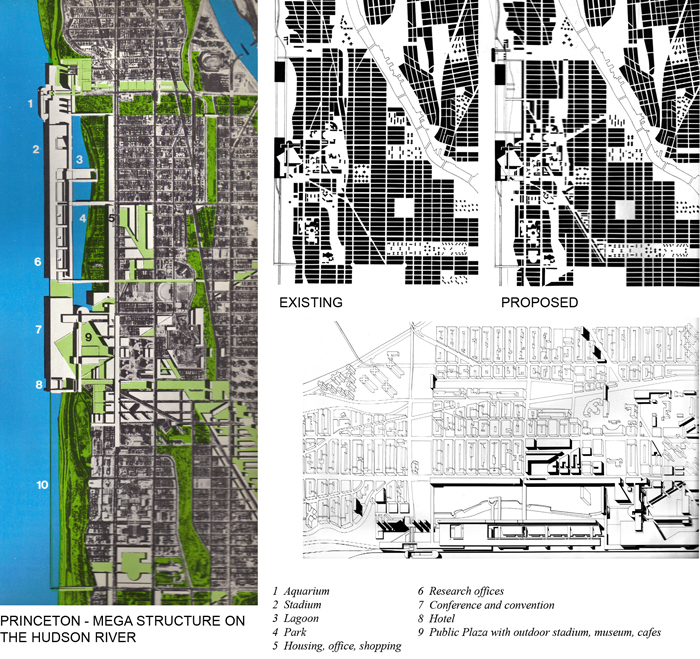
The Princeton project was located at the western edge of Harlem, along the Hudson River and extended east into the existing fabric – Figure 4. They stated the Problem: How can we make the waterfront both visible and useful, giving it an architectural weight that would relate it to major crosstown streets and lead to the development of new kinds of neighborhood and institutional centers? The Proposal statement was: The project calls for the termination of the 125th Street axis by a public plaza opening onto the Hudson River. The plaza provides the connecting link between the adjacent neighborhoods and the other elements for the new project. Largest of these is a two-building structure built over the river and extending thirty blocks north in a straight line. The project could be seen to relate to the investigations into megastructures of this period. It proposes to cut diagonal streets through the existing fabric north east to the Harlem River and south east to Morningside Park. It probably would require the eminent domain process that was instrumental for the Federal Urban Renewal program to achieve its removal of existing fabric.
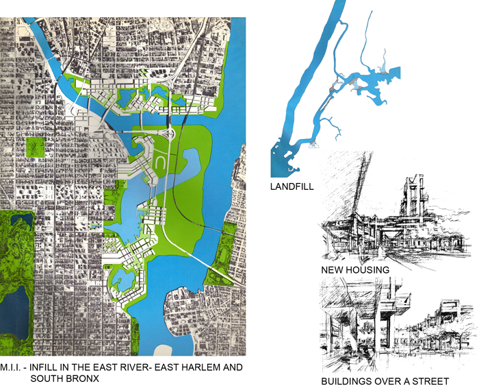
The MIT project was on the eastern edge of Harlem involving the edge at the east River and a portion of the South Bronx – Figure 5. It stated the Problem: How can we develop large segments of new land out of relatively under-used, or miss-used, peripheral areas, so that they alter the character of existing neighborhoods by providing important new amenities? Their Proposal: Randall’s and Ward’s Island and the southern tip of he Bronx should be developed. Land fill operations already undertaken by the Triborough Bridge Authority should be part of a consistent plan: the two islands should be connected to each other and to Manhattan This project is unrelated to the geometric grid of Manhattan even though it states a desire to be connected. By creating a completely different kind of urban fabric with water orientations, it becomes a kind of new town, opposite to the attempt to graft Battery Park city onto Manhattan in its 1960’s plan, and to which it could be compared. It might however be seen to presage the ideas of landscape urbanism that try to work with post-industrial sites. The project proposed a significant ecological modification that went undiscussed.
This was the first public presentation of the Cornell School of Contextualism. The Columbia project was a site-specific mega structure and more interesting than similar projects proposed earlier for Battery Park City. It was perhaps the most implementable. The Princeton project was also a mega structure proposal that recognized the potential for New York City to transform the waterfront from a working port to new uses. Its connection into the surrounding fabric, requiring removal of existing fabric, was questionable. The M.I.T. project ventured into the realm of land reclamation, utilizing an often used strategy to transform and develop New York City. However, its relationship to the morphological structure of upper Manhattan and the South Bronx was questionable.
Exhibiting urban designs by academics at the Museum of Modern Art was unprecedented and bold. The four projects were not avant-garde proposals. They were varied formal propositions for a site that, in the late 60’s, was socially charged. However, it perhaps should have been called, “Interventions for transforming the Existing City” rather than the “New City: Architecture and Urban Renewl”.
The Institute for Architecture and Urban Studies IAUS – the first year 1967-1968
After the MoMA – New City exhibition, Peter Eisenman approached Arther Drexler at MoMA to create an institute to study the issues that the exhibition presented and were debated The Institute for Architecture and Urban Studies, IAUS, was born with funding from MoMA and Cornell was also to come from funded projects. Graduate urban design students from Cornell University were to work on these projects with Colin Rowe and Peter Eisenman.
The Institute began in September 1967, six months after the MoMA exhibition, with Peter Eisenman to be the Director, Colin Rowe the teacher and four graduate students from the Cornell Urban Design grduate program. It was submitted to be Chartered by the Board of Regents of the State of New York to offer educational programs in 1967 and received it in 1969 (I was one of the students in the first year). The Institute closed in 1984, lasting 17 years (I was the Director of Education that last year).
In 1969 the Institute stated its mission; “As an alternative to academic studies and present practice of the profession, the Institute combines teaching, research and development into one process. To this end it coordinates the resources of the university, the museum, and public and private planning agencies.” They stated that it was, “ to bridge the gap between the theoretical world of the university and pragmatic world of the planning agencies.” The IAUS also wrote in 1969; “The major area of concern is with the problem of physical design as a problem solving device of structuring the urban environment understood as the active relationship between physical systems and social systems.”
There was some immediate press when it opened. Reyner Banham wrote; “Vitruvius over Manhattan”, in the British New Society journal in 1967(Dec.pg. 828-29). Writing of “The New City” exhibition at MoMA, organized by its director Arthur Drexler and Peter Eisenman, Banham discussed the formalism of the projects exhibited and stated that it was naïve to think that well-designed urban form could transform people. “They look to the city of good form, before the city of good men-but probably believing that the good form will breed good men, that a city which makes itself visually clear will become clear in other senses too.” The British historian, Robin Middleton also wrote about the Institute in his “Cosmorama” column in Architectural Design in 1968.
Peter Eisenman had organized a Conference of Architects for the Study of the Environment (CASE) in 1964. A second conference was organized in 1967 by the Institute at MoMA. Eisenman seemed to have had ideas about an American, academic oriented, Team X, where members would come together and present projects and papers.
The first Institute project came from the Urban Design Group, a special new department within the New York City Planning Commission of the Mayor Lindsay’s administration, formed with the Columbia team of the MoMA New City exhibition; Jonathon Barnett, Alex Cooper and Jacquelyn Robertson. The project was to be related to the Urban Design Group’s work on a planning document for the five boroughs of New York City. The New York City Planning Commission, with Donald Elliot, Chairman during mayor John Lindsey’s administration, published this as a six volume Plan for New York City in 1969. The first volume was Critical Issues, while the other volumes were devoted to the five Boroughs. They were intended to culminate in master plans, but resulted in a more systematic document of existing conditions along with projects that were being proposed, in each neighborhood of New York City.
The area given by the Design Group to the IAUS was Kingsbridge Heights in the north Bronx – Fordham Road to Gun Hill Road and Webster Avenue to Jerome Avenue. A master plan was not created, and as a result, the IAUS work, that proposed a plan, was not utilized by the Urban Design Group.
The IAUS study, that was competed in May 1969, was bound into a document by the Institute but was not published. Peter Eisenman wrote an introduction that explained his idea for IAUS. In it he stated; “the Institute is an attempt to provide an alternative in the learning experience; as a mechanism which could provide a true synthesis between the theoretical world of the university and the real world of the problems of our cities.” “While our primary interest is with the relationship of urban studies and urban problems, our second and more specific goal is how this method and form of education can be related directly to the problem of physical planning. It is through the process of teaching, research and actual commissioned studies by public an private agencies that we hope to understand the process of physical design and how it relates to the total planning process; how the process of physical design receives, translates, and evaluates information from other disciplines; how the physical environment affects the operation of a city and the life of an individual; and how this physical environment can be more rationally produced so that it can become more intelligible and understandable to the individual, and ultimately so that it can be implemented within the existing limitation of the economic, political and social structure. … “In other words, we are concerned with developing a theory of urban form which would have a direct influence on and, in fact, evolve from practical constraints in the actual planning process. This secondary objective is of necessity didactic in that there has been little study of the physical environment as a rationally conceived entity capable of being analyzed and evaluated.”
As Reynor Banham suggested, the Institute believed that urban design should be form driven and social, cultural, political and economic issues could be resolved in relation to formal manipulation. The ideas of Jane Jacobs, Herbert Gans, Kevin Lynch, Christopher Alexander and others arguing for the primacy of these other issues, played a negligible role in Institute thinking and production. The Institute’s addition of the sociologist Robert Gutman from Princeton began to change this orientation in following years.
Colin Rowe contributed an article; “A Contextual Strategy”. This brief article articulates Rowe’s ideas for the urban design program at Cornell. Rowe’s interests at the end of the 60’s were with the modern urbanist propositions of Le Corbusier; the building in the park, “a rationalization of modern building techniques…of movement and transportation…and the confrontations of buildings and trees…” He characterized the Ville Radieuse as, “a diagram. Basically, an argument against the existing city, it is, like so many polemical manifestations, just that much to simple, and its hyper-rational structure, its denial of the genuinely specific, its comparative lack of interest, its absence of meaningful complexity, all alike invite question.” Rowe contrasts this to the prevalent issues of “townscape”, “…that love of disorder, cultivation of the individual, distaste for the rational, passion for the various, and suspicion for the generalized…its nostalgia and retrospection”. Rowe saw a third movement emerging; “… a world where , apparently of necessity, megastructures which straddle superhighways are further relentlessly penetrated by monorails and minicars.” Rowe ends with notes; “Problem: we have 1. A criticism of the traditional city—ville radieuse; 2. A favorable appraisal of the traditional city—townscape. 3. A new idealization of the city as a prophecy theatre.” Roe found all three problematic and unable to propose a direction other than a possible combination of all three. The early Cornell Urban Design studios posed the issue of searching for a dialectical relationship or dialogue between the modern city in the park and the historical city. This was to propose a potentially more progressive stance than its forbearers and contemporaries; Camillo Sitte, Gordan Cullen, Jane Jacobs and Kevin Lynch who were interested in the existing city.
Regarding this first IAUS (unpublished) document, Eisenman stated in his article; “This publication is intended to initiate this kind of interchange of ideas. It is not concerned with a mere historical recording of the work of this year though it uses actual projects undertaken for the New York City Planning Commission during the past academic year merely as a vehicle.”
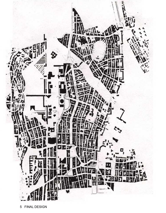
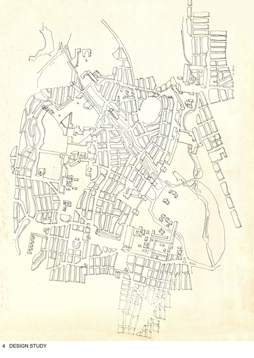
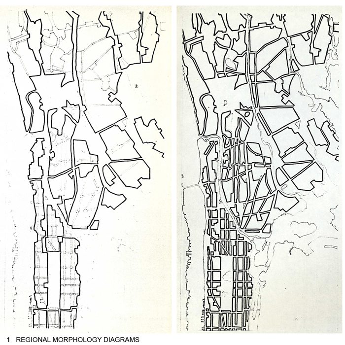
The project for the northern Kingsbridge Heights – Jerome Park area of the Bronx was ultimately a formal exercise. Population, land use and zoning, circulation and transportation, even assessed valuation of land and building information was collected, analysed and diagramed. Although new land use and zoning were included with the proposed development, the project was primarily a formal, spatial, morphological proposal. It followed the MoMA exhibition by a few months and the influence of the Cornell and Princeton projects is obvious. Many diagrams were made to analyze the existing formal structure of the site. The primary vertical north south, and minor east west striations and the diagonals were noted through an analysis of the existing morphology and utilized in a design that tried to clarify, reinforce and accentuate this existing formal structure. Like the Cornell MoMA project, very little existing fabric was removed or erased, as compared to the Princeton project, and thus it was a contextual proposal in the Cornell School manner. Given its centrality, the Jerome Park reservoir, that New York City was concurrently studying to remove, became a primary site for development. The rail tracks along the Bronx Park with the New York Botanical Gardens was also a significant site opportunity to densify and scale the edge of a large park. It became a demonstration of an alternative version of the megastructure proposal of the Columbia MoMa project. It proposes a rhythm of towers and slabs to produce an edge between the park and the city. A sequence of open spaces was to progress along this north-south edge, making east-west connections between fabric and park. Within these two sites, the linear striations that characterize the Bronx were clarified and enhanced along with the inherent, but minor diagonal structure.
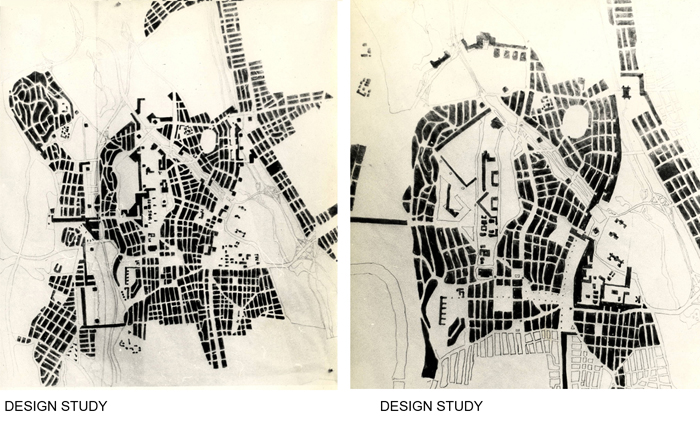
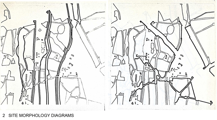
The images demonstrate a methodology for urban design that the Institute developed on this first project. Figure 6 is regional morphological analyses examining the orthogonal and diagonal structure of the territory. Figure 7 is the same kind of analysis of orthogonal and diagonal structure at a larger scale of the study site. The project was designed primarily in figure-ground plan. Figure 8 is the existing condition and a design study in figure ground drawing. Figure 9 sketches are the authors early studies emphasizing the orthogonal and the diagonal. . Abstract three dimensional projection diagrams were also employed to explore the volumetric readings of the plan – Figure 10. Figure 11 is the final project.
Illustrated here are only four of more than fifty such diagrams of this morphological structure. They are theme and variations, with the theme being the identification of the orthogonal and diagonal matrixes in the existing context, and the variations are the designs as hierarchical transformations of these geometrical discoveries. The city is interpreted as a modern architectural interplay of orthogonal and diagonal geometry often utilized in early modern architecture. It is a study in urban “phenomenal transparency” as defined by Colin Rowe and Robert Slutsky. By interpreting latent multiple geometries in the existing large and small scale context, and manipulating these to create urban designs, it demonstrates a relationship to cubist “iridescence” where pictorial space has been shattered into an endless collage of overlapping elements – Figure 12. Rarely complete in themselves, they find their organization by reference to larger elements often superimposed over them. These organizational geometries do not reside in the objects (cubist images become urban building form) themselves. The possibilities of combining various buildings within a system of order, which attributes to each piece a bit of the organization, become almost infinite.
Reminiscent of Eisenman’s diagrams of his own work, these urban design diagrams precede Eisenman’s architectural designs. One could postulate the influence of this early IAUS urban design methodology on Eisnman’s later architectural production. Likewise, Richard Meier’s Bronx, Twin Parks housing project of 1972, demonstrates working with the same ideas at the architectural scale (two of the IAUS students, Stephen Potters and I, became associates in Richard Meier’s office) – Figure 13.
The IAUS continued to engage urban projects for the next five years. From 1968 to 1970 it pursued a commissioned “New Urban Settlements” project, and in 1970, it began the “On Streets’ project with HUD support, that was published in 1978. These projects did not continue the exploration of urban design methodology that was begun with this first project in the Bronx. By 1972, with a second MoMA exhibition; “Another Chance for Housing”, the IAUS began to move away from urban issues. They occurred infrequently in Oppositions articles and for the next twelve years, the IAUS pursued more theoretical issues of architecture. It would be interesting to speculate on what effect it might have had on urban theory and production had the first exploration of the first IAUS project continued to be explored and developed.


